
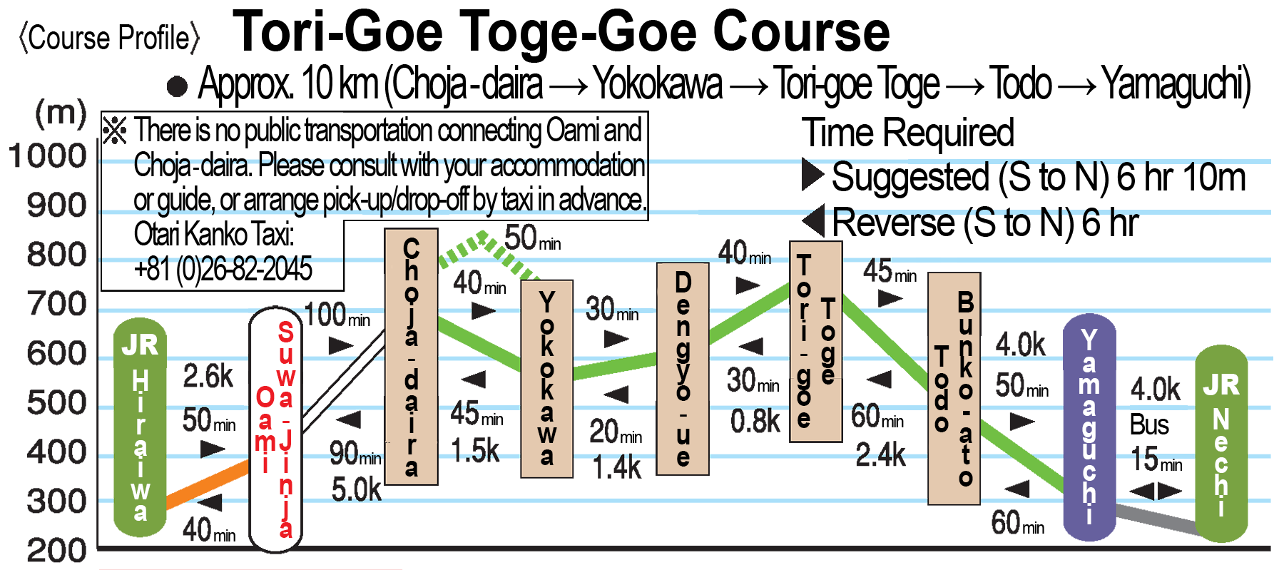
Torigoe Toge-goe Course
●Difficulty: Advanced, suitable for strong walkers
●Walking Period: June to first snowfall* (Please inquire about trail status and conditions.)
●Total Length: Approximately 10 km (Chojadaira → Yokokawa → Torigoe Toge → Todo → Yamaguchi)
● Time Required: About 6 hours 10 minutes from south to north / About 6 hours from north to south
Highlights
●Journey on the least-visited section of Otari’s 8 Salt Road Courses
●Search for signs of the settlements that once graced the trailside
●Marvel at the beauty of nature and the restorative power of isolation
●Tread on paths eroded by heavy human traffic and pack animals
●Visit the Todo settlement’s Sakai-no-miya shrine, the site of an ancient once-every-seven-year ritual that continues still today
The Torigoe Toge-Goe Course passes through now-quiet but historically-thriving territory that serves as a stark reminder of the geo-political and geographical forces that threatened and ultimately drove away, the communities that once lived here: a village burned by invading forces, a settlement whose fortunes faded as foot traffic was diverted from the Chikuni Kodo to the newer Kaido, and a now-abandoned border hamlet whose residents relented in the face of frequent landslides, heavy snow, and extreme isolation. Their story is the story of the Shionomichi, and a walk here is a powerful way to experience a different side of the Salt Road while still enjoying the excellent trails, religious monuments, attractive forests, and incredible views found all throughout Otari.
Elevation Profile
Access
By Car
Parking is available at the southern end of the course using the parking lot for the Hiraiwa Ideyu-no-Hiroba, along the Himekawa River a short distance from Hiraiwa Station, but keep in mind it’s approximately 3 kilometers / 50 minutes on foot to the Oami settlement, and another 5 kilometers / 100 minutes onward to Chojadaira. Alternatively, you can arrange a taxi, but be sure to confirm the fare and make a reservation in advance.
By Train
Hiraiwa Station is the closest and most convenient station for accessing Chojadaira at the southern end of the walk, but it’s still approximately 3 kilometers / 50 minutes on foot to the Oami settlement from there, and another 5 kilometers / 100 minutes onward to Chojadaira. Walking times are slightly less in the other direction. Or, once again, you can arrange a taxi, but be sure to confirm the fare and make a reservation in advance.
On the northern side, local buses connect Nechi Station to Yamaguchi.
Historical Landmarks & Points of Interest
-
Chojadaira
In the Warring States Period, this area was home to a large settlement of around 70 households populated by the same clan as Iimori Moriharu, but was burned down during a battle with Takeda Shingen’s forces.
-
Yokokawa
This area is said to have been one of the important relay points for good traveling along the Chikuni Kaido. Furthermore, archaeological digs have unearthed various examples of ancient Sue and Haji pottery here.
-
Dengyo
The area is designated as a ”Nature Exploration Park” in recognition of its natural scenery and scientific importance. Here beautiful clusters of beech trees and yuki-tsubaki snow camellias line the trail.
-
Ippon-sugi
-
Todo Kannon Dohyo
-
Todo
The remote Todo settlement straddles the border of Echigo (Niigata) and Shinshu (Nagano) and was once populated with around 30 households. Because of its location on the geopolitical border between provinces, and the natural border between the ocean and the mountains, it was an important waypoint on the Chikuni Kaido. It’s said to be the only settlement in Nagano that offers views of the Sea of Japan.
-
Hiyoshi-sha
-
Yamaguchi Sekisho-ato
This is the site of another key point along the old Chikuni Highway, where a guard station established by the Echigo Domain once sat. This guard station was strategically located on the domain’s border, and was used to monitor transportation, regulate trade, and collect tolls. Today, a stone monument marking the site is all that remains.